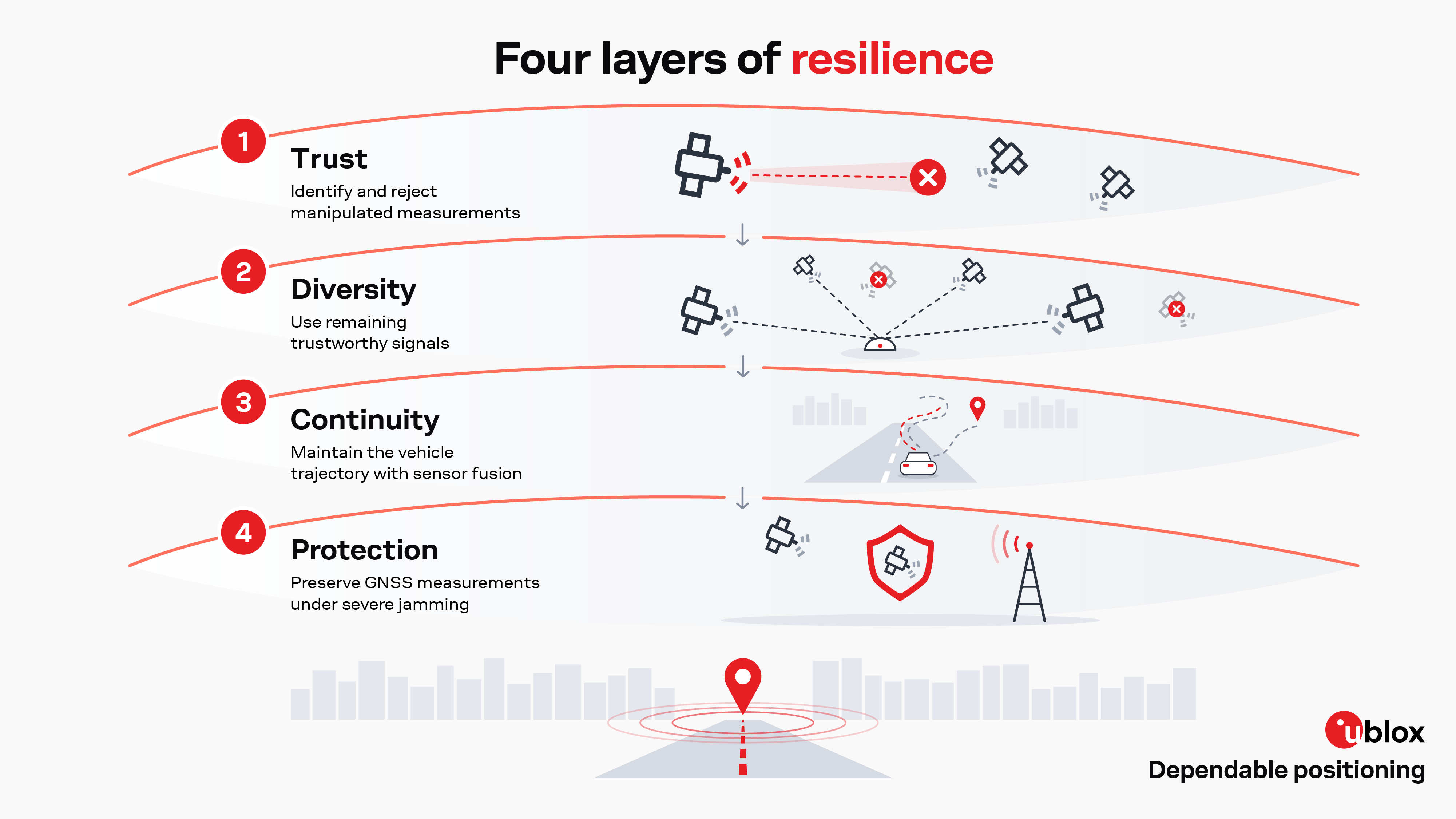


How u-blox maintains trustworthy positioning when GNSS is manipulated, degraded, or disrupted.
At Jammertest 2026 in Andøya, Norway, u-blox put this challenge to the test under real-world, controlled interference conditions. The campaign included meaconing, spoofing, and high-power jamming scenarios, allowing us to examine not only how receivers detect interference, but also how they select trustworthy measurements, maintain positioning, and recover as conditions change.
The results demonstrate that resilience is not a single capability. It can be built in layers: identifying and rejecting manipulated measurements, making use of signal diversity, maintaining the vehicle trajectory with sensor fusion, and protecting GNSS reception against severe jamming.
Together, these capabilities move resilient positioning beyond detection alone. In last year’s Jammertest blog, we focused on integrity: detecting interference and determining whether the GNSS solution could still be trusted. This year, we take the next step toward continuity: maintaining a useful and trustworthy positioning solution when GNSS is manipulated, degraded, or disrupted.
Join our experts to explore what Jammertest 2026 means for real-world GNSS resilience.
Register for the Jammertest 2026 webinar now
Positioning continuity is more than simply continuing to output a position. It means maintaining a useful and trustworthy positioning solution as GNSS conditions deteriorate.
When GNSS signals are manipulated or disrupted, a resilient receiver must identify trustworthy measurements, prevent deceptive or untrustworthy signals from driving the navigation solution, and make use of other available information when GNSS alone is no longer sufficient.
Depending on the interference scenario, this can mean selecting trustworthy measurements from the available GNSS signals, using signal diversity to maintain positioning, transitioning to sensor fusion when GNSS becomes unreliable, or protecting GNSS reception against severe jamming.
The goal is therefore not simply to keep reporting coordinates, but to maintain a dependable positioning solution.
Jammertest is an annual open-air GNSS/PNT (positioning, navigation, and timing) resilience test held at Andøya, Norway, where positioning technologies are evaluated under controlled, real-world interference conditions. The campaign brings together public authorities, industry, and research organizations to test receivers and complete positioning systems against jamming, spoofing, and meaconing.
Unlike laboratory testing, open-air testing exposes systems to the complexity of live GNSS signals and over-the-air interference in a real environment. Jammertest 2026 provided multiple test areas, including stationary and dynamic scenarios, allowing u-blox to examine how positioning systems respond as signal conditions change.
For u-blox, the value of Jammertest goes beyond determining whether a receiver is affected. The focus is on understanding which measurements remain usable, how the navigation solution responds, and whether positioning can remain trustworthy as interference evolves.
Jammertest 2026 was the fifth time u-blox participated in the campaign, providing an opportunity to evaluate positioning technologies under conditions that are difficult to fully reproduce in a laboratory.
Jammertest 2026 comprised four test areas across Andøya, providing different environments for evaluating positioning resilience. For this campaign, u-blox conducted tests in two of these areas: Test Area 1 at Bleik and Test Area 3 at Stave.
Both locations supported dynamic testing, while their different test configurations enabled us to investigate complementary interference and positioning scenarios. At Test Area 1, we conducted controlled meaconing, spoofing, and high-power jamming tests, including the protected-reception evaluation using CRPA and NavPRISM technologies. At Test Area 3, we focused on dynamic vehicle scenarios, including the motorcade test used to evaluate sensor-fusion positioning continuity.
Together, the two test areas provided a broad set of conditions for examining how positioning systems detect interference, maintain trust in the available measurements, preserve positioning continuity, and recover as GNSS conditions change.
The tests conducted across the two selected Jammertest areas examined different aspects of positioning resilience. Together, they demonstrate four complementary capabilities: identifying trustworthy measurements, making use of signal diversity, maintaining positioning continuity through sensor fusion, and preserving GNSS measurements under severe jamming.
| Test | What we tested | Key Question | |
|---|---|---|---|
| 1. Dual-band low-power receiver under meaconing | Trustworthy measurements | Can manipulated measurements be identified and rejected while trustworthy measurements remain usable? | |
| 2. All-band GNSS receiver under multi-source meaconing | Signal diversity and integrity | Can signal diversity help maintain a trustworthy positioning solution when the available GNSS signals become inconsistent? | |
| 3. Sensor-fusion positioning continuity | Sensor fusion | Can the vehicle maintain a useful trajectory when GNSS becomes unreliable? | |
| 4. CRPA + NavPRISM under severe jamming | Protected GNSS reception | Can usable GNSS measurements be preserved under severe interference? | |
Test Area 1 | Event 3.3.1 | Low-power dual-band receiver comparison
Meaconing is a type of spoofing attack in which authentic GNSS signals are captured, delayed, and retransmitted. Because the signals are genuine, a receiver may continue to track them normally while gradually drifting away from its true position. Without integrity monitoring, the receiver may have no indication that its navigation solution has been manipulated.
Having multiple GNSS bands available does not automatically make a receiver resilient to manipulation. The receiver must also be able to determine which measurements can be trusted. In Test 3.3.1, a meaconing signal was transmitted from RX1 while the power was progressively increased from 0.001 W to 10 W and then decreased in 5 dB steps. Each power level was maintained for two minutes, allowing us to observe how the receiver responded as the level of signal manipulation changed.
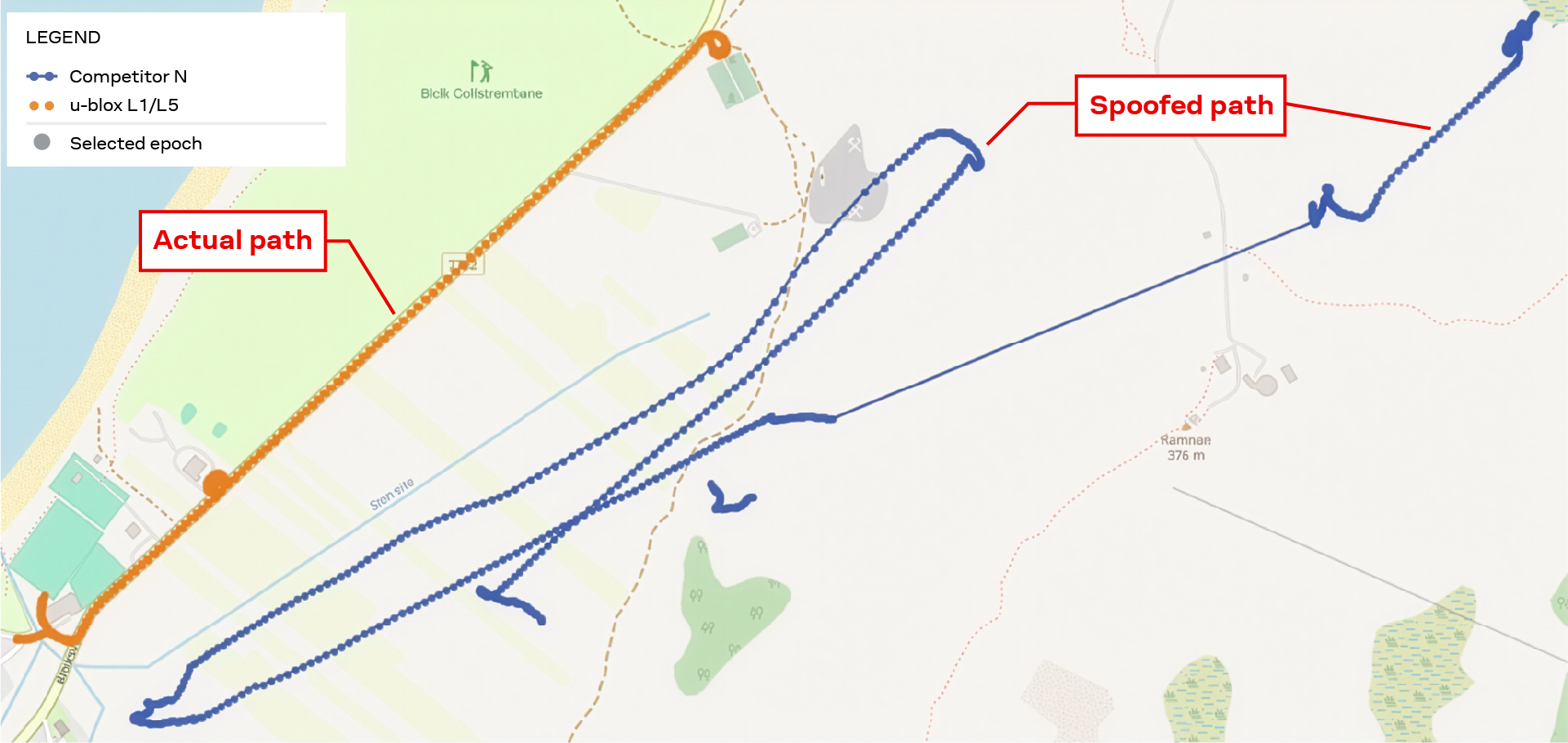
Key Result 1: Trajectory comparison under L1 meaconing
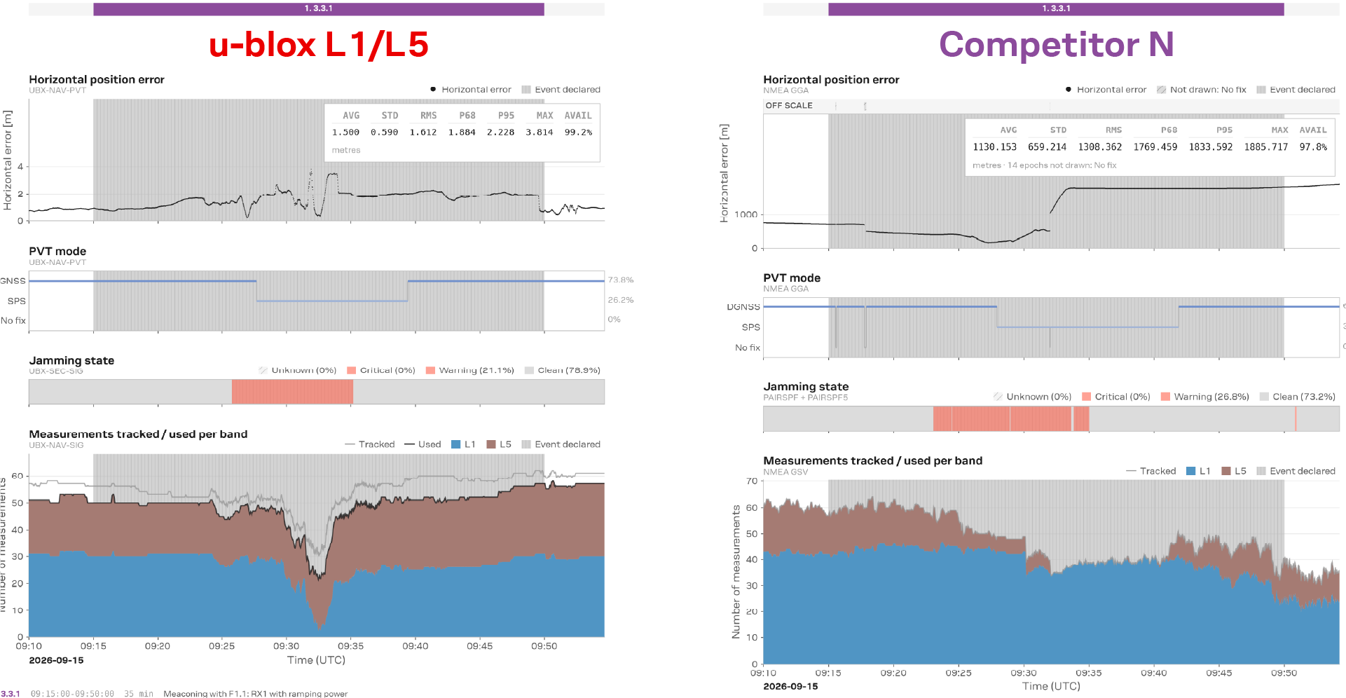
Key result 1: Horizontal error, PVT mode, and band usage during the meaconing interference
The results illustrate how the L1 meaconing attack affects the two frequency bands differently. As the attack power increases, the u-blox receiver progressively reduces the contribution of the manipulated L1 measurements while continuing to use measurements from the L5 band. This trusted-band selection preserves positioning integrity throughout the event.
The behavior is visible in the “Measurements tracked/used per band” plot. L1 measurement usage drops sharply near the peak of the attack, while L5 continues to support the navigation solution. The receiver temporarily transitions from DGNSS1 to SPS2 but maintains continuous positioning, with an average horizontal error of 1.51 m and a maximum error of 3.81 m.
The comparison receiver behaved differently. It continued to rely primarily on the manipulated L1 measurements while reducing its use of the unaffected L5 measurements. As a result, its position was progressively drawn toward the rebroadcast signals, with horizontal error eventually exceeding 1.8 km.
The result highlights an important aspect of multi-band positioning: resilience depends not only on the availability of multiple bands, but on the ability to identify which measurements remain trustworthy and prevent manipulated signals from driving the navigation solution.
[1] Differential GNSS (DGNSS) improves positional accuracy with corrections from reference stations at precisely known locations. SBAS corrections were used.
[2] Standard Positioning Service: Autonomous GNSS positioning without SBAS
Test Area 1 | Event 3.6.1 | u-blox’s all-band receiver versus three competitor receivers
When deceptive signals are present across multiple sources and the signal environment changes over time, maintaining a trustworthy position becomes more challenging. Signal diversity can provide more information to the navigation engine but only if the receiver can recognize and manage inconsistent measurements.
In Test 3.6.1, the u-blox all-band GNSS receiver was compared with three competitor receivers under a changing multi-source meaconing scenario. Deceptive GNSS signals were alternated between two locations, with one emitter active at a time and short overlaps during the handovers. This created an intentionally inconsistent signal environment in which the receiver had to determine which measurements could be used for positioning.
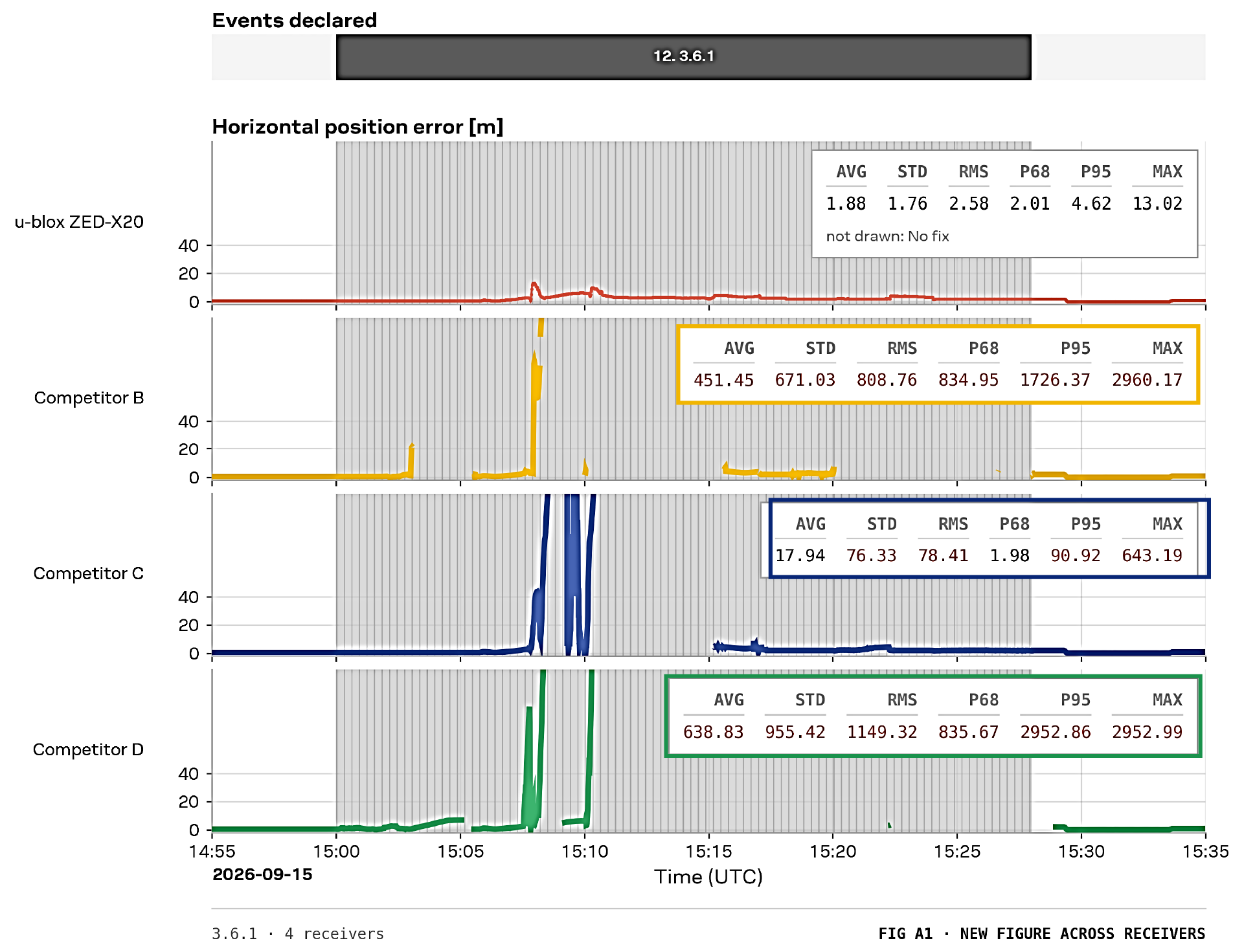
Key Result 2: Horizontal error comparison during multi-source meaconing
u-blox Horizontal error remains in the meter range; RTK Fix 80.7%; No fix below 0.1%; jamming and spoofing states expose the abnormal environment. |
Competitor B Horizontal error reaches about 2.9 km; No fix 16.6%; limited threat indication relative to the observed positioning impact. |
Competitor C Two excursions above 600 m followed by sustained no fix; No fix 10.5%; spoofing-state output unavailable. |
Competitor D Repeated errors around 1.1-2.5 km, with a peak near 3 km; No fix 2.0%; warning continues even when interference ends. |
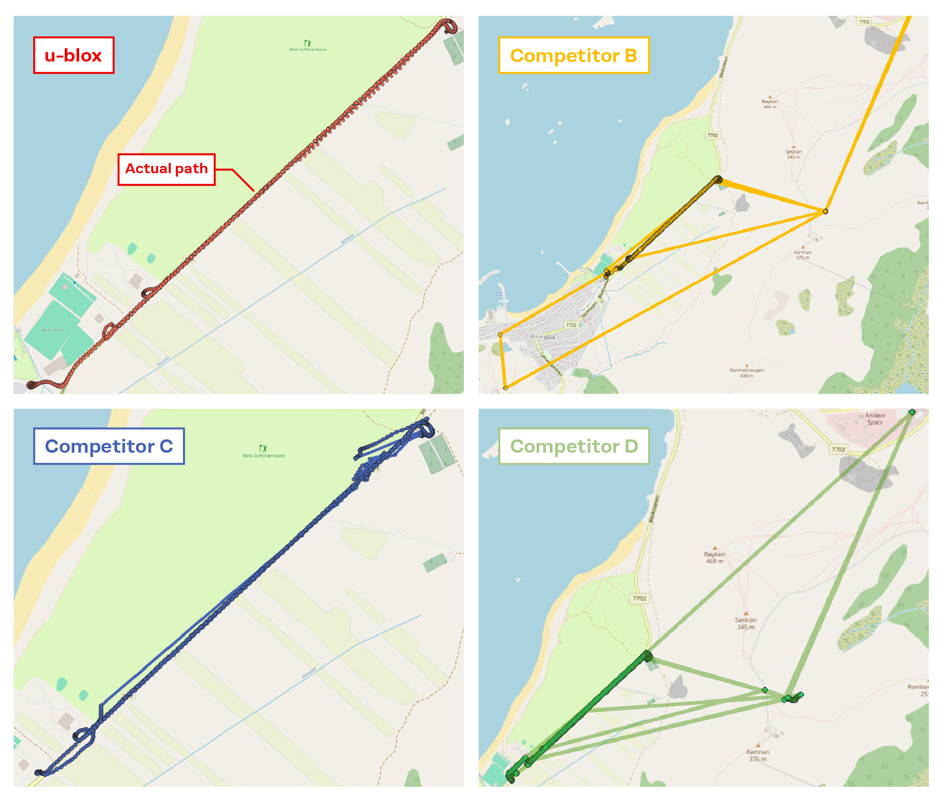
Key Result 2: Trajectory comparison under multi-source meaconing
A comparison against the ground-truth reference revealed markedly different behavior under the multi-source meaconing scenario. The u-blox all-band GNSS receiver kept horizontal error predominantly within the meter range while indicating abnormal operating conditions. The comparison receivers experienced false-position errors ranging from hundreds of meters to several kilometers, interrupted fixes, or both. The results show that maintaining a position output is not sufficient. The receiver must also recognize abnormal signal conditions and ensure that inconsistent observations do not drive the navigation solution.
Using more bands and constellations does not guarantee a trustworthy position. The receiver must recognize when the available measurements become inconsistent, prevent deceptive signals from driving the navigation solution, and use the remaining trustworthy information whenever possible.
But what happens when trustworthy GNSS measurements are no longer sufficient to maintain the required positioning solution? The next test moves beyond GNSS measurements and examines how sensor fusion can maintain the vehicle trajectory when GNSS becomes unreliable.
Join our experts to explore what Jammertest 2026 means for real-world GNSS resilience.
Register for the Jammertest 2026 webinar now
Test Area 3 | Motorcade | Continuing through degraded or unavailable GNSS
When trustworthy GNSS measurements become limited, resilience cannot rely on GNSS alone. Sensor fusion can provide another layer of protection by combining GNSS with inertial and vehicle information to maintain the vehicle trajectory.
In Test 2.6.6 at Stave, a spoofing transmitter was mounted on a vehicle in the motorcade. The vehicles initially remained stationary for five minutes, allowing a fixed spoofed position to be established near the starting location. The motorcade then began moving at 35 km/h while the spoofed GNSS position remained fixed. This created a growing inconsistency between the actual vehicle motion and the position presented by the spoofer.
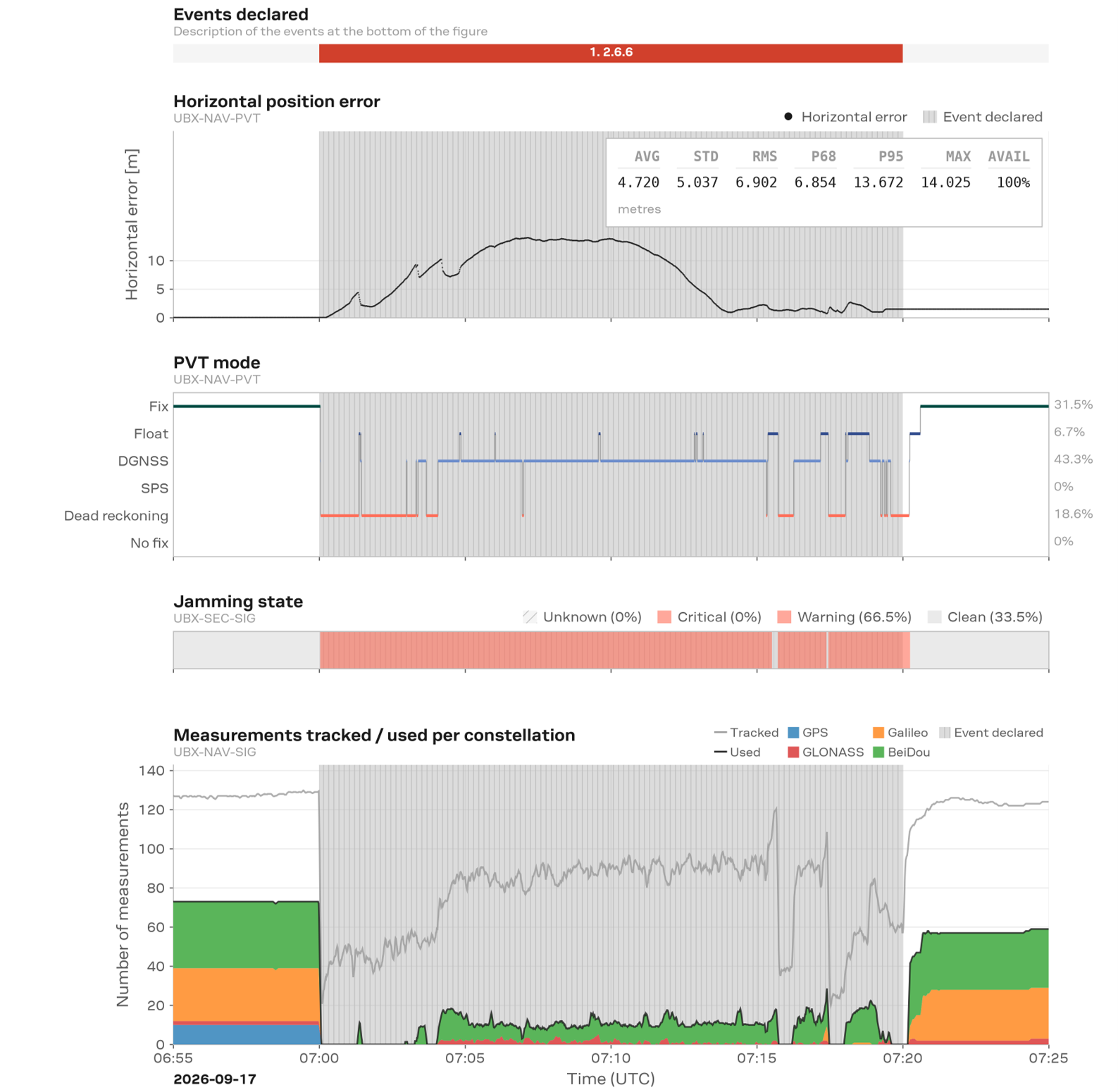
Key Result 3: Positioning continuity during the motorcade spoofing test
As the motorcade moved away, the spoofed GNSS position remained fixed near the starting point. The fused solution did not follow this false position. When trustworthy GNSS measurements became limited, the receiver used dead reckoning to continue propagating the vehicle trajectory. The horizontal error initially increased to approximately 13 m, but decreased again as suitable GNSS measurements became available and were reintegrated into the solution.
Across the plotted session, the receiver operated in RTK Fix, Float, DGNSS, and Dead Reckoning modes, with no time spent in No Fix. When GNSS trust was reduced, the solution could transition to dead reckoning and continue propagating the vehicle position rather than dropping the positioning solution.
The number of measurements used by the navigation solution dropped sharply at the beginning of the event. The solution was subsequently rebuilt primarily using BeiDou measurements, with additional contributions from GLONASS and Galileo. This illustrates that the receiver did not simply continue using every available signal; it continued with the subset considered usable while supported by sensor fusion.
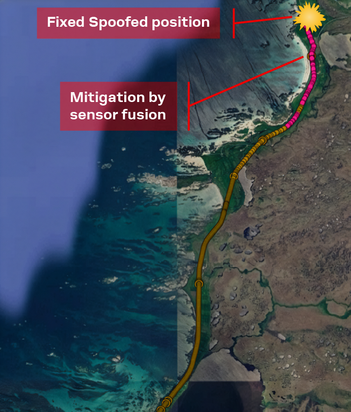
When trustworthy GNSS measurements become limited, sensor fusion allows the navigation solution to continue using inertial and vehicle information until suitable GNSS measurements become available again. Without sensor fusion, the trajectory may be lost during this gap, making recovery more difficult. The u-blox sensor-fusion solution combines all-constellation and all-band GNSS with inertial and vehicle information, allowing the navigation solution to propagate through the disruption and reintegrate trustworthy GNSS measurements when they become available again.
Key Result 3: Vehicle trajectory during the motorcade test
A resilient positioning system should not maintain continuity by accepting an untrustworthy GNSS position. Instead, when GNSS measurements become unreliable, sensor fusion can help maintain the vehicle trajectory using inertial and vehicle information until suitable GNSS measurements become available again.
Sensor fusion can maintain continuity when GNSS measurements become temporarily unreliable or unavailable. Another approach is to protect GNSS reception itself, preserving more measurements before interference can remove them from the navigation solution.
Test Area 1 | Dynamic Test 1.8.2 | 50 W PRN jamming pyramid
When interference becomes severe, maintaining a trustworthy positioning solution also depends on preserving the GNSS measurements available to the navigation engine. Antenna-level interference mitigation can reduce the impact of jamming before it compromises the receiver’s usable measurements.
In Dynamic Test 1.8.2, a 50 W PRN3 jamming sequence progressively introduced interference across multiple GNSS bands, starting with L1 and adding G1, L2, L5, E6, B1I and G2. The bands were then removed in reverse order until only L1 remained. Each five-minute step consisted of three minutes of active jamming followed by two minutes without jamming.
The plots below illustrate the number of GNSS measurements that are actively used by the receiver during a PRN jamming scenario. The first graph shows the measurements used per constellation, while the second shows the measurements used per frequency band. The bottom plot indicates the receiver positioning mode throughout the test.
As the pyramid jammer increases in complexity, individual GNSS signals are progressively targeted. The sequence begins with GPS L1, followed by GLONASS G1, GPS L2, and then GPS L5. By the later stages of the test, the PRN jammer is affecting most of the available signals across multiple constellations and frequency bands.
[3] PRN jamming: Interference generated using pseudo-random noise codes that resemble GNSS signals in spectrum
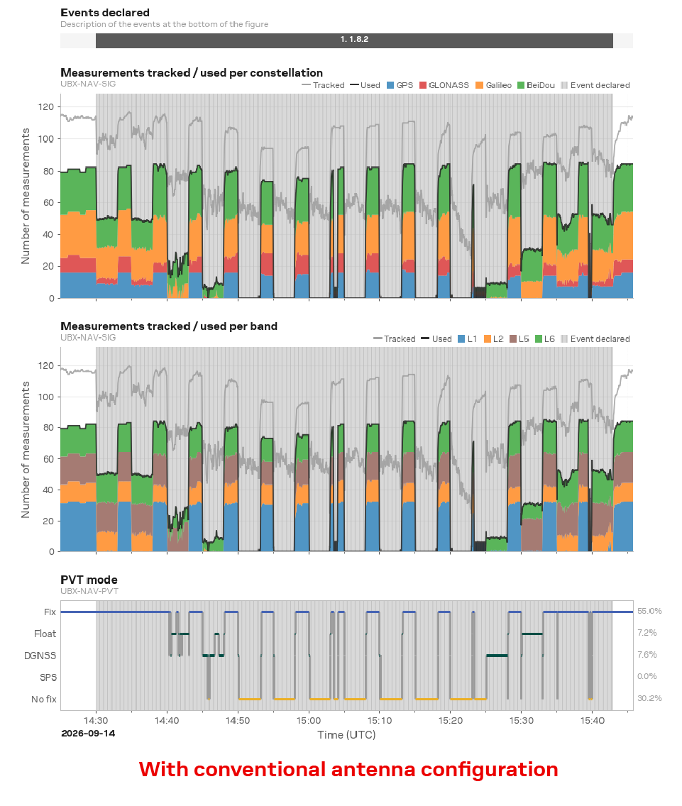 Key Result 4: Usable measurements repeatedly fall sharply and approach zero during severe multi-band stages | 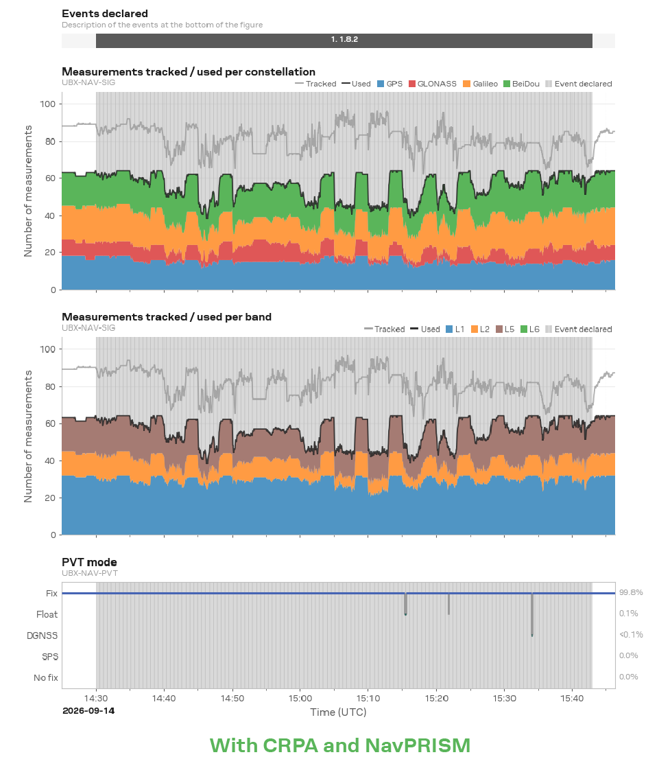 Key Result 4: Measurements remain available across GPS, GLONASS, Galileo and BeiDou, and across L1, L2, and L5 |
With a conventional antenna, the number of usable measurements drops dramatically as additional signals are jammed. Eventually, most measurements are lost, resulting in extended periods with insufficient observations for positioning. This directly impacts navigation performance, with the receiver maintaining an RTK fix only 55% of the time and spending approximately 30% of the test without any position fix.
In comparison, the CRPA-enabled receiver maintains RTK fix for approximately 99% of the test, with only brief transitions away from RTK fix. A Controlled Reception Pattern Antenna (CRPA) uses multiple antenna elements and adaptive beamforming techniques to suppress interference arriving from the jammer direction while maintaining sensitivity toward legitimate satellite signals. Together with NavPRISM (Positioning Resilience and Interference Mitigation) resilience technologies, this allows a significantly larger number of GNSS measurements to remain available throughout the test, even under severe multi-signal jamming conditions.
By preserving GNSS measurements despite severe interference, the CRPA-enabled system demonstrates a key NavPRISM principle: resilient positioning starts with maintaining signal availability.
The positioning results show the outcome, but the RF-spectrum plots help explain why the two configurations behaved differently. They visualize the interference reaching the receiver during the same jamming sequence. Within each plot, brighter colors indicate stronger received RF energy. The repeating patterns show when interference affects the monitored GNSS frequency regions. The AGC trace shows how the receiver front end responds to changing RF power.
In the conventional-antenna configuration, the repeating high-energy patterns show the three-minute jamming periods affecting multiple GNSS frequency regions. This interference progressively reduces the measurements available to the navigation engine, eventually causing repeated loss of RTK fix and periods without a position solution.
With the CRPA configuration, the interference signature is substantially reduced. By suppressing interference arriving from the jammer direction, the CRPA protects the GNSS signals before they reach the receiver. Together with NavPRISM, this allows more measurements across multiple bands and constellations to remain available, enabling the navigation engine to maintain RTK fix through nearly the entire test.
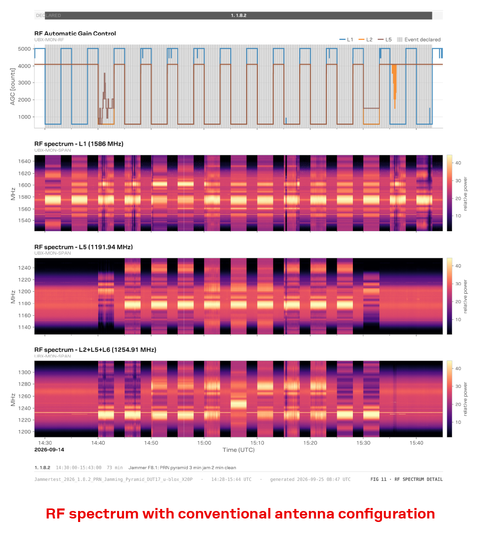 Key Result 4: Strong periodic interference is visible across multiple GNSS frequency regions, corresponding to the repeated loss of usable measurements | 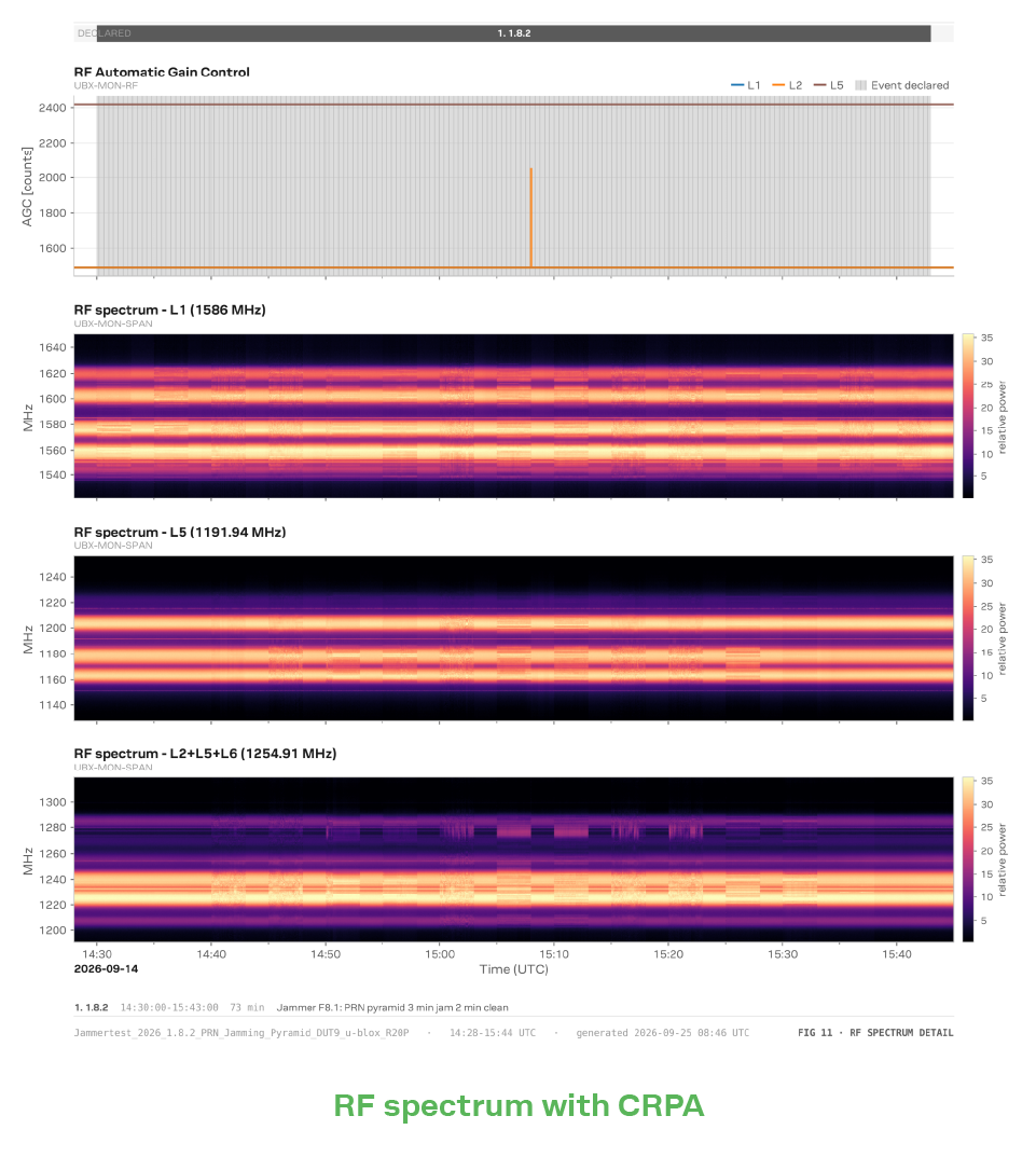 Key Result 4: The reduced interference signature shows the protection delivered before the signals reach the receiver, helping preserve measurements across multiple bands and constellations | |||||||
| How to read the RF-spectrum plots: Time progresses from left to right, with alternating jamming and clean periods. Frequency increases from bottom to top, with each heatmap representing a GNSS frequency region. The AGC trace shows the receiver front-end response to changing RF power. | ||||||||
Jammertest 2026 demonstrated that resilient positioning cannot depend on a single mechanism. Different threats require complementary layers of protection: identifying trustworthy measurements, using signal diversity intelligently, maintaining the trajectory through sensor fusion, and protecting GNSS reception under severe jamming.
Together, these capabilities reflect the u-blox approach to resilient positioning. They move resilience beyond simply detecting that GNSS has been compromised, helping positioning systems continue using trustworthy information, adapt as conditions change, and maintain a dependable navigation solution wherever possible.
This is the progression from integrity to continuity. Resilient positioning is not about continuing to report coordinates at any cost. It is about maintaining a position that can still be trusted.
Join our experts to explore what Jammertest 2026 means for real-world GNSS resilience.
Register for the Jammertest 2026 webinar now
Get in touch for orders or any queries: sales@rfdesign.co.za / +27 21 555 8400
Courtesy of u-blox